
40 Fascinating Before & After Photos Of New York City
I’ve always loved going to New York City. I love walking everywhere, riding the subway like I know what I’m doing, and eating my way through neighborhoods one restaurant at a time.
The city just feels alive in a way no other place does. But what really blows my mind is how much it’s changed over the years.
These before-and-after photos from @nyc.beforeandafter show the same streets and buildings across decades, and it’s like watching time happen in fast-forward.
It’s part history lesson, part nostalgia trip, and a reminder that even the most iconic city in the world is always becoming something new.
1. 1979 & Today

Looking southwest down Henry St from Market St in Two Bridges, Manhattan.
Off in the distance of the old photo loom one of the most iconic fixtures in the history of New York City’s skyline: the Twin Towers. When the photo was taken, the Twin Towers had only been completed several years earlier with the North Tower (on the right with the antenna) opening in 1972 and the South Tower (on the left) opening in 1973. The Twin Towers held the title of tallest buildings in the world only for a few of years before being surpassed the Chicago’s Sears Tower in 1973. However, the towers would retain the title of tallest in NYC for 3 decades until they met their tragic demise during the 9/11 attacks.
What I find particularly amazing about the old photo is how you can literally see the evolution of NYC’s skyline. Lining both sides of Henry Street are 19th century tenements. Next, the domed building above them is the Manhattan Municipal Building which was completed in 1914. To the left is the Woolworth Building which, when completed in 1913, was the tallest building in the world. And now, 66 years later, the Woolworth Building finds itself completely dwarfed by the massive Twin Towers. At present, the scene remains virtually unchanged save for the for the clear absence of the Twin Towers. Today, rising above the new WTC site, One World Trade Center holds the title of tallest in NYC, the U.S, the Western Hemisphere, and 5th-tallest in the world.
This post is dedicated to the 2,977 victims, their loved ones, the first responders, and everyone else affected on and in the aftermath of the most tragic day in our nation’s modern-day history: September 11, 2001. Never forget.
2. 1916 & Today

Looking south on 7th Ave from W 26th St in Chelsea, Manhattan.
On this day, 118 years ago, the New York City subway system first opened to the public. The first subway line contained just 28 stations and ran from City Hall north to 145th Street. Today, the subway system contains 24 routes and 3 shuttles that cover a whopping 472 stations spread across 4 of the 5 boroughs. With millions depending on it every day, the subway is truly the critical engine that drives New York and it is difficult to imagine the city having developed into the metropolis that it is today without this vital piece of infrastructure.
Of course, the subway didn’t just spring into existence out of nowhere; it had to be built. The old photo above shows 7th Avenue completely dug out and several men hard at work down on the construction of the IRT Broadway-Seventh Avenue Line. The primary form of construction during the subway’s early years was the so-called cut-and-cover method that would involve hundreds of men having to dig up a roadway, building the system and stations, and finally roofing it all and restoring the roadway up above.
Early subway construction was certainly a dangerous occupation and most workers were unskilled immigrants who received very low wages, with many undoubtedly being injured in accidents over the decades. So, on the subway’s 118th birthday, taking a moment to reflect and appreciate the back-breaking work and lives that so many persevering men gave in order for millions today of the nation’s largest city to be able to get from Point A to Point B.
3. 1951 & Today

Looking northeast on Broadway & 7th Ave from W 45th St in Times Square, Manhattan.
.
The principal subject featured in the old photo is the lovely and iconic actress, Audrey Hepburn, who is gazing up the numerous Times Square signs and advertisements. Around the time that the photo was taken, Hepburn was in New York to play the title part of Gigi on the Broadway show of the same name. “Gigi” would run for over 6 months from November 24th, 1951 to May 31, 1952 at the now-demolished Fulton Theatre on 46th Street. Hepburn would go on to break into the motion picture industry not long afterward and would achieve stardom in Hollywood before returning to New York in 1961 to play the character of Holly Golightly in the hit film “Breakfast at Tiffany’s”.
4. 1960 & Today

Looking south at the intersection of 7th Ave & Sterling Pl in Park Slope, Brooklyn.
On Dec. 16, 1960, the deadliest aviation disaster in the world up to that point occurred over the skies of New York City as United Airlines (UA) Flight 826 and Trans World Airlines (TWA) Flight 266 collided in midair over Staten Island. UA Flight 826 was a DC-8 plane bound for Idlewild Airport (now JFK Airport) while TWA Flight 266 was a Lockheed Constellation bound for LaGuardia Airport. The TWA flight went down almost instantly after the collision and crashed in Miller Field on Staten Island. UA Flight 826 lost an engine and part of its right-wing in the collision but remained airborne before ultimately going down in Park Slope a few minutes after 10:30 AM.
The crash produced a large explosion that shook through the neighborhood and scattered wreckage in all directions, as well as setting fire to several brownstone buildings, a church, and numerous businesses. Remarkably, there was initially 1 survivor from the flight discovered at the crash site; Stephen Baltz, an 11-year old boy from Illinois. Baltz was thrown from the plane upon impact and landed in a snow pile. Despite being rushed to the hospital, Stephen sadly passed away the following day, bringing the total toll from the disaster to 134. The cause of the collision was later determined to be that the United flight flew beyond it’s allocated airspace designated by air traffic control.
5. 1900’s – 1910’s & Today

Looking north on the east side of 5th Ave from E 34th St in Midtown Manhattan.
.
Hurry, hurry, hurry! There’s still time to get your Christmas shopping done! Though unlike the people seen in the old photo you can’t get that shopping done at the B. Altman & Company department store given that it no longer exists. The store was founded on Manhattan’s Lower East Side in 1865 by Benjamin Altman. Largely designed in a Renaissance Revival style, the company’s flagship store on Fifth Avenue opened in 1906 and takes up an entire city block from between 34th and 35th Streets and 5th and Madison Avenues. Altman’s would operate out of the building for over 8 decades before the company filed for bankruptcy in 1989 and ceased operations.
.
Since its glory days as a department store, the building today has been repurposed and primarily houses the CUNY Graduate Center. Did you ever visit Altman’s on 5th Avenue back in the day? Feel free to let me know in the comments section down below! And if you do decide to get your last-minute Christmas shopping done, please bundle up and stay warm! It’s cold outside!
6. 1936 & Today

Looking north toward the Hell Gate Bridge from the Astoria Pool in Astoria, Queens.
.
The old photo was taken during Astoria Pool’s inaugural summer season, having been opened on July 2, 1936. Framed by the Hell Gate Bridge to the north and the Triborough Bridge (off-screen) to the south, the Astoria Pool was 1 of 11 large public swimming pools built in 1936 with funding from the Works Progress Administration. .
The construction of the pool, Astoria Park, and the aforementioned Triborough Bridge were all overseen by-then New York City Parks Commissioner Robert Moses. However controversial his legacy might be today, Astoria Pool is most certainly one of the positive things to come out of his decades-long tenure in New York City urban planning. Featuring lovely Art-Deco design elements, the pool measures in at 330 by 165 feet and is the largest of the 11 WPA pools and was designed to accommodate up to 5,500 bathers at a time!
.
The pool immediately became popular with locals, especially children, who would visit it on a daily basis during the scorching New York summers of an era before air conditioning was widely available. Only 2 days after its opening, the pool would host Olympic Trials for the U.S Swim and Diving Teams ahead of the 1936 Olympics in Berlin. The Trials produced several winners, including gold medal swimmers Jack Medica and Adolph Keifer. The pool would go on to host Olympic Trials again in 1952 and 1964 ahead of the Games in Helsinki and Tokyo respectively. Astoria Pool remains open to this day and was designated a New York City Landmark in 2006.
.
Meanwhile, the 1,017-foot Hell Gate Bridge opened in 1916 as a railroad bridge and connects Queens to Randalls and Wards Islands. The bridge was also the inspiration for the design of the famous Sydney Harbour Bridge in Australia, which opened in 1932.
7. Early 1950’s & Today

Looking north on Lexington Ave from E 102nd St in East Harlem, Manhattan.
.
Want a taste of the hilly San Franciscan experience without leaving NYC? Well, then head uptown to Duffy’s Hill, one of the steepest sections in Manhattan with a grade of 12.6%. Back in the day several trolley accidents would occur here as a result of the cars having to rapidly accelerate and decelerate when ascending or descending the hill. The trolleys are long gone but the M101, M102, & M103 bus routes still make the climb today.
Note in the old photo how Lexington Avenue was originally paved with Belgian Block and supported two-way traffic. This traffic pattern ended in 1960 when Lexington Avenue switched to only carrying one-way traffic southbound.
8. 1950’s & Today

9. 1992 & Today

Looking west on Plymouth St from Washington St in DUMBO, Brooklyn.
The old photo is a still taken from the 1992 Martin Brest film “Scent of a Woman” starring Al Pacino and Chris O’Donnell. In the scene, the characters of Lieutenant Colonel Frank Slade and Charlie Simms are pulled over by a cop after a memorably thrilling sequence in which Pacino’s character—who is blind—test drives a 1989 Ferrari Mondial T Cabriolet through the streets of DUMBO. Like many films and tv shows set in New York prior to fateful September in 2001, the Twin Towers were an essential part of the backdrop, boldly proclaiming to the viewer “This is New York”. I think it’s fair to say that cinematographer Donald E. Thorin did the Towers justice in this shot.
The Twin Towers are no longer here, of course, and neither is the parking lot on the right-hand side. Today, that area forms part of the 85-acre Brooklyn Bridge Park. The new One World Trade Center isn’t visible from this spot due to the trees, but head a block down the street and you’ll be treated to a commanding view of it, the Brooklyn Bridge and the rest of the Lower Manhattan skyline.
10. 1946 & Today

Looking east on Edgemere Ave at Beach 44th St in Edgemere, Queens.
There’s still time for some fun in the sun before the summer’s out, and nowadays you won’t even have to worry about the swimsuit police. Up until around the early 1960’s most places used to enforce strict sets of laws which dictated what was and was not appropriate for people to wear on public beaches. Anyone deemed “indecently dressed” could expect to receive a fine or even face arrest in some cases. The old photo of today’s post shows a woman receiving such a fine from a police officer. Note the sympathetic smile the woman in the background seems to be giving to her ticketed counterpart.
Men were not safe from swimsuit police either. Simply being shirtless was enough to warrant being fined. Ultimately, the laws concerning beach attire were gradually relaxed over the years and or became unenforced.
11. 1941 & Today

Looking south down 10th Ave from W 18th St in Chelsea, Manhattan.
A ghost. That is the term that some by the mid-20th century might’ve used to describe the proverbial American cowboy; a character which by then belonged to the history books & to eternity in the man-made purgatory that was the “Western” film genre. However, unbeknownst to many, the cowboy actually continued to live on for several more decades after the conquest of the west in an entirely unexpected setting: New York’s West Side.
The “West Side Cowboy” came about as a result of the New York Central Railroad building freight train tracks running up and down 10th & 11th Avenues in 1847. Unlike the elevated passenger trains of later decades, these freight trains actually ran at street-level with no barriers or dividers to protect vehicles and pedestrians from crossing paths with oncoming trains. As a result, the railroad would hire “cowboys” whose job it would be to ride on horseback ahead of the moving trains while waving flags to signal that a train was approaching. However, even with the cowboys, hundreds of accidents would occur over the decades.
Led by Robert Moses, the 1929 West Side Improvement Project sought to eliminate the street-level railroad crossings by constructing an elevated viaduct for freight trains to safely run on. The viaduct debuted in 1934 but some trains would continue running on 10th Ave for 7 more years. The old photo in this post was taken March 29, 1941, and shows 21-year-old George Hayde and his horse Cyclone: the last “West Side Cowboy” leading the last train. Today, that 1934 viaduct is the iconic High Line park.
12. 1980 & Today

The Lower Manhattan skyline from across the Hudson River in Jersey City, New Jersey.
The old photo shows 2 girls walking along the derelict Jersey City waterfront with New York’s imposing Twin Towers looming across the Hudson. The Twin Towers were not even 10 years old when the photo was taken and the entire World Trade Center complex had still yet to be fully completed as seen by the construction of 3 World Trade Center (later known as the Marriott World Trade Center) between the two towers. The separate World Financial Center closer to the shoreline where the Winter Garden Atrium is located had also yet to be built, allowing for a fully unobstructed view of the Twin Towers from New Jersey.
Construction on the World Trade Center began in the late 1960’s on the site of the former neighborhood of Radio Row. The North Tower was completed in 1972 & the South Tower in 1973. Each tower stood at 110 stories tall & were the tallest buildings in the city; 1 WTC being the taller of the two as a result of its antenna spire. Combined, the towers provided nearly 10 million sq ft of office space for about 35,000 people. The WTC complex was a city within a city. During the 3 decades that they stood, the Twin Towers became an integral part of New York’s cityscape and it was hard to find a tv show or movie set in New York from that time without the Twin Towers featured prominently in at least one scene. It was simply impossible to imagine New York without them…
Today, the new One World Trade Center, completed in 2014, stands just north of the former site of the North Tower & holds the title of the tallest building in the city and the Western Hemisphere.
This post is dedicated to the 2,977 victims, their loved ones, the first responders, and everyone affected on or by Sep. 11, 2001. Never forget.
13. 1980 & Today
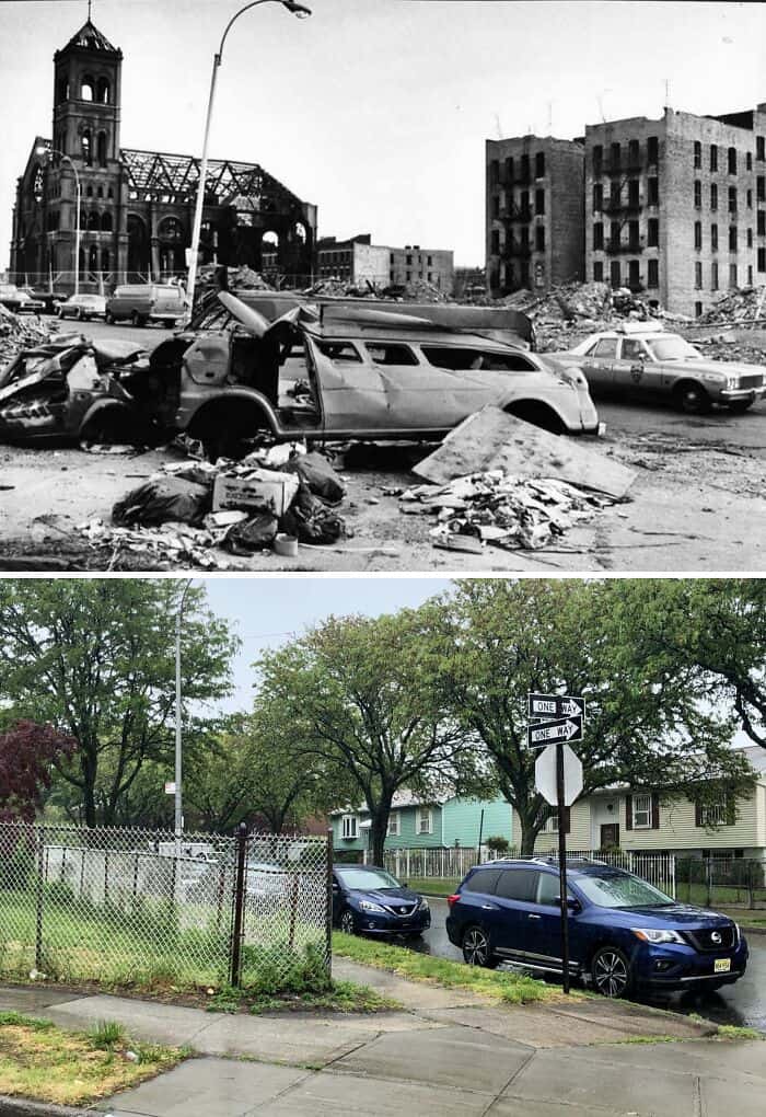
Looking NE on Seabury Pl from Charlotte St in Crotona Park East, The Bronx.
.
What you are looking at is not some fictional imagining of a post-apocalyptic future but rather the real & horrid reality that was the Bronx during the 1970’s & 80’s. During this time, it was not uncommon to see large sections of, or even entire neighborhoods completely reduced to rubble with large burnt out apartment buildings interspersed among the bleak & desolate landscape.
.
It can be argued that the decline of the Bronx began following WWII. Whilst we tend to look back on this time as being one of nationwide prosperity, this was not necessarily the reality for minorities in America’s cities. In 1955, the Cross Bronx Expressway opened, a project spearheaded by Robert Moses that required the demolition of hundreds of buildings in mostly working-class Black & Puerto Rican neighborhoods, & resulted in the displacement of over 60,000 residents. The end result was entire communities being left physically divided & polluted, which, in turn, caused property values to plummet.
.
By the 1960’s, as quality of life declined, many residents, particularly middle-to-upper class Whites, began to leave the Bronx in favor of the suburbs. By the late 60’s, many landlords & building owners saw little to no point in maintaining their underpopulated apartment buildings, causing them to fall into a state of disrepair. As a result, many chose to purposely burn them in order to collect the insurance money. By the end of the “Decade of Fire”, many areas of the Bronx lay in ruins & it would be many years before some neighborhoods began to recover. This specific zone’s recovery began during the 1980’s & today it’s known as Charlotte Gardens.
14. Early 1950’s & Today

Looking north on 3rd Ave toward E 85th St in Yorkville, Manhattan.
I admit that when I got to this spot in order to recreate the photo for this post, I was amazed to see that the sidewalk clock seen in the old photo was still standing after all these years! In fact, the clock has actually been around since 1898! Designed to resemble a pocket watch, the clock was originally located on the northwest corner of 3rd Avenue & East 85th Street in front of the jewelry store of Adolph Stern. The clock was moved to its current spot in 1923 in front of a new pawn shop that Stern had opened. In 1981, the Yorkville Sidewalk Clock was designated a NYC Landmark.
.
One thing that has not survived the test of time however, besides the numerous buildings, is the elevated IRT Third Avenue Line. Opened in 1878, at its greatest extent the line ran from South Ferry on the southern tip of Manhattan all the way north to Gun Hill Road in the Bronx. Eventually, by the time of the Great Depression, the el’s had come to be seen in a negative light with many deriding them as loud and dirty antiquated relics of a bygone era which negatively affected property values all along their routes in contrast to the underground subways. One by one, the el’s began to come down and by 1942, following the demolitions of the elevated IRT Sixth, Ninth, and Second Avenue Lines, the Third Avenue El was the last fully elevated line left on the island of Manhattan.The Third Avenue El would live on until 1955 when the line between South Ferry and 149th Street was closed and subsequently demolished.
15. 1955 & Today

Looking north on Broadway toward W 37th St in the Garment District, Manhattan.
The old photo shows the 31st annual Macy’s Thanksgiving Day Parade back when the parade route went down Broadway toward Macy’s flagship store at 34th Street. Since 2009, the parade’s route no longer runs down Broadway but instead reaches Macy’s via 6th Ave. The first parade kicked off in the midst of the Roaring Twenties in 1924 and is tied with Detroit’s as the oldest annual Thanksgiving parade in the nation.
The idea of a parade was mainly intended as publicity for Macy’s flagship store, the world’s largest store which had only just opened in 1922. The inaugural parade’s route started way uptown at Convent Ave & West 145th St and ran for 6 miles down to Macy’s on 34th St. Over 250,000 people turned out to see the grand spectacle which culminated with Santa Claus climbing atop a marquee above Macy’s store’s entrance and taking his place on a throne where he was crowned “King of the Kiddies”. So successful and popular the parade turned out to be that Macy’s announced the following morning that they would conduct another parade the following Thanksgiving, and thus, a New York tradition was born.
1927 was the first year in which the parade featured the presence of the giant inflatable balloons that have since become an iconic staple of the annual parade tradition. And though the parade was suspended from 1942-44 due to shortages of rubber and helium during World War II, since then, the parade has continued to be an annual event, even taking place in 2020 albeit significantly scaled back.
16. 1935 & Today

Looking south on W 12th St from Bowery St in Coney Island, Brooklyn.
The only thing that is present in both photos is the iconic Wonder Wheel. The NYC Landmark was designed by Charles Hermann and originally opened on Memorial Day, 1920. The Wonder Wheel stands at 150 ft tall – roughly equivalent to a 15-story building – weighs over 200 tons and has 24 cars, of which 16 are swinging and 8 are stationary. For 6 decades the ride was owned operated by Hermann’s son, Fred, until it was sold to Denos D. Vourderis in 1983. The Vourdeis family restored the wheel and today it is the star attraction of Deno’s Wonder Wheel Amusement Park.
.
In the old photo can also be seen an attraction known as “Scoota Boats” (an electric boat ride) and a ride known as the Virginia Reel. Both most likely lasted into the 1960’s before they were demolished. The roller coaster seen in the present-day photo is new, having just opened this year. It is known as The Phoenix and also forms part of Deno’s Wonder Wheel Amusement Park.
17. 1895 & Today

The south side of Rockaway Blvd from 83rd St in Ozone Park, Queens.
July 13, 1895, was shaping out to be just an ordinary day in the suburb of Woodhaven, Queens (today, this area is part of Ozone Park). Then, at around 4:18 PM, a massive dark funnel-shaped cloud between 200 & 300 yards wide suddenly appeared & came barreling down toward the unsuspecting residents below. It was a tornado.
Upon reaching town, the tornado uprooted trees, [destroyed] livestock, & ripped houses right off their foundations. Numerous buildings had their windows blown in & several people who were caught outdoors were lifted right off the ground and flung through the air. The old photo of today’s post shows a house in the aftermath of the storm. The worst damage occurred at the recently-built PS 59 brick schoolhouse at Rockaway Blvd & 95th Ave with the building left completely destroyed Thankfully, because it was summer, the school was empty at the time of impact. Tragically, the tornado would claim 1 life that day; that of a 16-year-old French girl named Louise Petroquien. Louise had recently married a man who worked at the nearby Lalance & Grosjean Factory on Atlantic Ave. When she saw the tornado approaching, she ran out of her house to warn her mother who was out in the garden when a beam that had been ripped off of the PS 59 schoolhouse flew and struck her in the head. The next day, a 5-year-old boy named Johnny Kolb who’d been rescued from rubble after the tornado also died from his injuries.
Following the tragic storm, thousands of people came from miles around, especially from Manhattan & Brooklyn, to view the devastation. Tornadoes are, of course, a rarity in New York City and are typically associated with Tornado Alley out west, but they can occur anywhere and at any time as the residents of Woodhaven sadly found out.
18. 1947 & Today

Looking west from 5th Ave between W 49th & W 50th Sts in Rockefeller Center, Manhattan.
The tradition of the annual Christmas tree in the heart of Rockefeller Center dates back to 1931 when the massive complex was still being constructed. On that year’s Christmas Eve, construction workers on the site pooled their money together and bought a 20-foot high balsam fir which they decorated with handmade garlands, strings of cranberries, and a few tin cans provided by the workers’ families. Two years later in 1933, Rockefeller Center decided to make the Christmas tree and annual tradition and the first official lighting ceremony was held that year with a 50-foot high balsam fir.
.
The annual tradition continued for the next few years even as World War II kicked off. During the war, the tree was decorated in patriotic colors of red, white, and blue, and in 1942, due to material shortages, 3 smaller trees instead of one massive one, were erected instead. The tree also went unlit 1944 until the war’s end due to the city’s wartime blackout regulations. 1951 was the first year the annual tree lighting was broadcast on television by NBC. The lighting broadcast on NBC now averages around 5-6 million viewers annually. The tree seen in the 1947 photo was 65-foot high Norwegian spruce from Deer Park, New York. This year’s tree is a 79-foot high Norwegian spruce that hails from Elkton, Maryland, the first time a tree from that state has been chosen as the official Rockefeller Center Christmas tree.
19. 1903 & Today

Looking north Broadway toward W 79th St on the Upper West Side, Manhattan.
The old photo was taken just 1 year prior to the opening of this section of the IRT Broadway-Seventh Avenue Line; part of the first subway line in New York City that ran from City Hall up to 145th Street. 79th Street is one of the original 28 stations from the subway’s inauguration and it looks as though it was still receiving finishing touches prior to its grand debut. 79th Street station was designated a NYC landmark in 1979 and added to the National Register of Historic Places in 2004.
.
The only other thing besides the station entrance remaining is the First Baptist Church in the City of New York on the upper left-hand side of both photos. The church was opened in 1894 and designed by George Keister, the man who would later go onto to the design the famous Apollo Theatre in Harlem. Keister designed the facade in an Italian Romanesque Revival style and situated the building at a 45-degree angle so that it would embrace the busy Broadway intersection. To this day the building is still active as a house of worship.
20. 1940’s & Today

Looking north from the SW corner of Northern Blvd & Bell Blvd in Bayside, Queens.
The original White Castle restaurant seen in the old photo opened on this busy Bayside corner back in 1932. Before McDonald’s and Burger King came around in the 40’s and 50’s, respectively, White Castle—founded in 1921 and known for its 5 cent square hamburgers and innovative food assembly process—reigned supreme as America’s premier fast food chain. In the early days, White Castle’s castle-shaped locations were small, measuring no more than 200 sq. ft., (18.581 m²). Due to this reduced seating capacity, customers were encouraged to live by the company’s slogan “Buy ‘em by the sack”, where one could buy a sack of five burgers to take out instead of dining in the restaurant.
The 1932 White Castle building was torn down in the 1960’s in order to expand seating capacity. In the 80’s, after burning down in a fire, the new restaurant was moved slightly north of its original corner location in order to accommodate a drive-thru. Though the original 30’s building is gone, it’s amazing that this location has remained active for over 90 years.
21. 1905 & Today

Looking north on 9th Ave toward W 53rd St in Hell’s Kitchen, Manhattan.
The old photo shows the aftermath of the worst elevated train disaster in NYC’s history. The IRT Ninth Avenue elevated line opened in the late 1870s and ran from South Ferry up to 155th Street. The sharp curve seen in the old photo was a spur that ran along W 53rd St & allowed trains to connect the IRT Sixth Avenue El to the east.
On Sep. 11, 1905, during the morning rush-hour, a southbound 9th Ave El was mistakenly switched onto the curve by a switchman. The tight curve had a maximum speed limit of 9 mph, but the motorman failed to notice a signal stating the train’s route had been switched and so the train entered the curve at 25 mph. The lead car cleared the curve but the 2nd derailed and fell onto the street below. The 3rd car came to hang off the edge of the trestle in front of the apartment building to the right, with some passengers even climbing out onto the fire escape after the accident.
In the aftermath, the switchman, Cornelius Jackson, & motorman, Paul Kelly, were found guilty of 2nd-degree manslaughter. Kelly actually escaped the city after the accident and was found and arrested in San Francisco 2 years later. Jackson served 5 years in prison and Kelly served 2 and a half years. In 1909, Kelly & another inmate escaped Sing-Sing prison up the Hudson River but were recaptured shortly afterward. The 9th Ave El would continue operating until 1940, when the line south of 145th Street was closed and demolished.
22. 1983 & Today

Looking east toward the Lower Manhattan skyline from Hudson St and Second St in Jersey City, New Jersey.
This cool retro photo shows 2 unidentified couples, each sharing a romantic moment, on a derelict pier with the Twin Towers looming across the Hudson River. When this photo was taken, the Twin Towers had only been fully completed some 10 years earlier. Despite that short amount of time, it did not take long for the two massive 110-story marvels of engineering to cement their places as integral icons of New York City; a city desperate to rejuvenate itself after having fallen on some pretty hard times. The Twin Towers would reign supreme over the New York skyline for just under 3 decades before their tragic destruction during the 9/11 attacks in 2001.
.
Today, the new One World Trade Center stands just north of where the North Tower once stood and holds the title of of the tallest building in New York, the United States, the Western Hemisphere, and 5th-tallest in the world. The Jersey City waterfront has seen much change since the 80’s. During the 90’s, this area underwent large-scale revitalization and is now known as Exchange Place and contains a concentration of high rise office and residential buildings.
.
This post is dedicated to the 2,977 victims, their loved ones, the first responders, and everyone else affected on and in the aftermath of one of the most tragic days in modern history: September 11, 2001. Never forget.
23. 1946 & Today

Looking south down Pike St at Madison St on the Lower East Side, Manhattan.
Well… uh… the Manhattan Bridge is still there! Tragically, all of the old tenement buildings seen in the old photo were demolished around the early 1960’s as part of the city’s urban renewal policy and as part of the widening of Pike Street. On the left side of the present-day photo is the Rutgers Houses public housing development. The glass structure behind the housing complex is One Manhattan Square which was completed in 2019.
24. 1906 & Today

Looking south on Broadway & 7th Avenue from W 46th St in Times Square, Manhattan.
Times Square—the place where generations of New Yorkers and tourists alike have gathered to usher in the New Year as the iconic glittering ball makes its descent atop the roof of One Times Square. When the old photo was taken, however, there was no annual ball drop yet. No. That wouldn’t take place until the following year in 1907 when New York Times owner Adolph Ochs, in a bid to outdo his previous practice of a fireworks display from atop the roof of the Times headquarters, decided to initiate the now-world famous ball drop. Ever since, the ball drop has taken place each year save during 1942 and 1943 as a result of World War II blackout restrictions.
And so we bid farewell to 2025. It’s hard to believe we’re already more than halfway through this most hectic decade that is the 2020’s. I’m hoping I’ll be able to announce something momentous involving this page sometime next year, so stay tuned for that! 2026 is also shaping up to be a big year for the city as well with the World Cup (as well as the coveted final) coming in summer. Also, for the first time-ever, there will actually be a SECOND BALL DROP! Yes, you heard that right! In honor of America’s 250th birthday, Times Square will host a special ball drop at midnight on July 4th, 2026 to commemorate the ratifying of the Declaration of Independence.
From myself to wherever you may be, I wish all of you a happy and prosperous 2026!
25. 1900 & Today

Looking south on 5th Ave from opposite W 25th St in the Flatiron District, Manhattan.
The old photo offers us one of the last glimpses of Gilded Age New York; an age that would soon give way to the Progressive Era during the early years of the 20th century prior to World War I. On left a pair of fashionably-dressed ladies stroll beside Madison Square Park and past a line of horse-drawn cabs waiting to pick up passengers. The iconic Flatiron Building was yet to begin construction and the Fifth Avenue Hotel seen on the right was still standing. The Flatiron Building would rise above the neighborhood in 1902 whilst the hotel would be demolished in 1908 and replaced by the existing building at 200 Fifth Avenue. Also, note how the trees on the right in the old photo appear to have been replaced sometime between then and now.
26. 1900’s & Today

Looking west on the Brooklyn Bridge toward the Manhattan Tower, Manhattan.
On this day 140 years ago, May 24, 1883, the Brooklyn Bridge officially opened to the public for the first time & at last provided a connection across the East River between New York City & the then city of Brooklyn after 14 years of construction. Over 150k people turned out & crossed the span on that day with festivities lasting well into the night & ships in the East River firing off hundreds of fireworks that lit up the sky.
The Brooklyn Bridge was the brainchild of civil engineer John A. Roebling who drew up his design for the span in 1867. Tragically, he died of tetanus in 1869, never living to see its completion. His son Washington then set out to complete his father’s project. Hundreds of men worked around the clock both above ground & underwater with many of those working underwater falling victim to decompression sickness, including Washington in 1870 with him being bedridden for years afterward. During his ailment, his wife Emily would essentially take over his work by overseeing construction & managing day-to-day operations while reporting back to him. That the bridge was completed at all is due in large part to Emily’s management, so it was only fitting that she was chosen to become the 1st person to officially cross the bridge on opening day.
Today, the Brooklyn Bridge is an iconic New York & American landmark with over 160k vehicles; 30k pedestrians; and 4,000 cyclists crossing its span daily. Truly, it would be hard to imagine New York having become the metropolis it is today without the Brooklyn Bridge; an enduring testament to the city’s unbreakable spirit & to what America as a nation can achieve when her people all come together.
27. 1956 & Today

Looking east on E 80th St from 5th Ave on the Upper East Side, Manhattan.
Smiling as radiant as ever in the old photo is actress Grace Kelly outside her New York apartment building at 988 5th Avenue. Just a few weeks after the photo was taken, Ms. Kelly would leave the silver screen and the States for good when she married Rainier III, Prince of Monaco, in one of the most high-profile royal weddings of the 20th century.
Grace Kelly’s first major film role was in the 1952 western High Noon where she starred alongside Gary Cooper. Next came 1953’s Mogambo with Clark Gable & Ava Gardner. In 1954, aged 25, Kelly won the Academy Award for Best Actress for her role in the film The Country Girl. However, Kelly is perhaps best well-known as the leading lady & favorite of director Alfred Hitchock’s famous blonde muses during his golden era. Under Hitchock’s direction, Grace Kelly would star in Dial M for Murder (1954), Rear Window (1954), & To Catch a Thief (1955). Her surprise engagement & marriage to the Prince of Monaco (whom she met in 1955) left a void in Hitchcock’s films which he struggled to fill in subsequent years. In an alternate universe, we might’ve seen Grace Kelly star in Vertigo, North by Northwest, & maybe even Psycho!
Princess Grace would have three children with Prince Rainier III (including Prince Albert II, the reigning Prince of Monaco) & would be active in various charitable organizations throughout the rest of her life. Tragically, she would lose her life as a result of injuries sustained from a car accident after she suffered a cerebral hemorrhage while at the wheel on Sep. 13, 1982. The princess would die from her injuries the following night at the age of 52. She is buried inside the Cathedral of our Lady Immaculate in Monaco.
28. 1958 & Today

Looking east at the intersection of Montague St & Hicks St in Brooklyn Heights, Brooklyn.
Although, thankfully, all of the buildings seen in the 1958 photo are still standing, the hideous scaffolding surrounding the former Hotel Bossert certainly detracts from what would otherwise be a wholesome present-day scene.
The 14-story, 224-room hotel was built in 1909 by a local lumber magnate named Louis Bossert. In its heyday, the Bossert was nicknamed “The Waldorf-Astoria of Brooklyn” as it was one of the borough’s most opulent hotels. In the 1920’s, a restaurant called Marine Roof opened on the hotel’s roof offering guests incredible panoramic views of Brooklyn and Lower Manhattan across the East River. In 1955, the Brooklyn Dodgers celebrated their first and only World Series title whilst in Brooklyn at the Bossert.
Sadly, the Bossert saw a decline in the years following the 1950’s and the building was ultimately bought by the Jehovah’s Witnesses in 1988. The Witnesses were responsible for massive renovations that helped restore much of the former hotel’s charm of decades past that had long since been left to rot and decay. The building was once again sold in 2012 to Joseph Chetrit and David Bistricer who planned to turn the Bossert into a boutique hotel. Unfortunately, practically no actions to reopen the hotel were taken and the building has remained abandoned to this day. According to a Brooklyn Eagle article from Sep. 13, 2022, the building will soon be up for auction after the owners defaulted on a $112 million mortgage. Thus, the future of the former Hotel Bossert remains, as of now, uncertain.
29. 1936 & Today

Looking west at the SE corner of Broadway & 65th St in Woodside, Queens.
The old photo shows a group of people gathered around one of the entrances leading down to the 65th Street station. The station opened in 1933 as part of the IND Queens Boulevard Line’s first phase from Jackson Heights-Roosevelt Avenue to Queens Plaza and on to Manhattan via the 53rd Street tunnel. Built during the height of the Great Depression, the opening of the line was tremendously influential in spurring development throughout the various Queens neighborhoods it ran through, including Woodside. As early as the 1920’s, when plans for a Queens subway line with direct access to Manhattan were first proposed, speculators began buying up what was then still mostly rural farmland and properties all along the line’s proposed route in order to turn a profit. The apartment building in the background, as well as the row of mixed commercial and residential buildings across the street were all built just a few years prior to the line’s opening.
Though I can’t be 100 percent certain, I believe that this particular old photo was taken on December 31st, 1936. My reasoning for this is that that day marked the opening of the second phase of the Queens Boulevard Line east from Jackson Heights-Roosevelt Avenue to Kew Gardens-Union Turnpike. The policeman standing in front of what looks to be the cordoned-off entrance, as well as the people’s excited expressions, seem to suggest a celebratory occasion.
30. 1916 & Today

31. 1965 & Today

Looking east toward the New York State Pavilion in Flushing Meadows-Corona Park, Queens.
Built for the 1964-65 World’s Fair, the New York State Pavilion was designed by architects Phillip Johnson and Richard Foster, and structural engineer Lev Zetlin. It consisted of a theater called Theaterama, 3 observation towers, & a large elliptical structure called the Tent of Tomorrow. The 250 by 450 ft Tent seen in both photos originally featured a multi-colored suspension cable roof held up by sixteen 100-ft-tall concrete towers. The floor also featured a huge terrazzo highway map of New York State created by Texaco. The Pavilion was one of the Fair’s most visited attractions, and the Tent in particular was the site of many art exhibitions, concerts, & fashion shows.
Following the ‘65 season, the World’s Fair Corporation planned to demolish the Pavilion along with the Fair’s other large structures. However, Robert Moses and the state government lobbied for its preservation, with Moses in particular having been very enamored with the views offered by the observation towers & envisioned retaining the structure as a Queens landmark. In the end, the state provided $750k in Dec. 1965 in order to bring the buildings up to the city’s building codes, and ownership would be transferred to the city in 1968. The Tent became a concert venue for a time in 1969, and later operated as a roller rink from 1972-74 before closing due to damage to the roof. The roof was removed in the late 70’s, but the Tent would still be closed to the public in the 80’s due to safety concerns. Restoration efforts are currently underway at the Pavilion, with the Tent having been repainted, and with what remained of the terrazzo map on the floor preserved.
32. 1930’s Or 40’s & Today

Looking east on Pell St from Doyers St in Chinatown, Manhattan.
It’s refreshing to see that most of the buildings seen in the old photo still stand today and have remain largely unaltered. Note the elevated structure seen on the right side of the old photo and the buildings behind it that have since been demolished. The structure carried IRT Second Avenue Line trains until 1942 and IRT Third Avenue Line trains until 1955 before being demolished. The aforementioned buildings were razed to make way for the present 44-story Confucius Plaza apartments complex.
33. 1957 & Today

Looking west across the East River from the Brooklyn Heights Promenade in Brooklyn Heights, Brooklyn.
Despite how much the Lower Manhattan has changed over the course of the mid-20th century up to the present, the 3 skyscrapers featured prominently in the old photo still stand today! From left to right are 20 Exchange Place, 40 Wall Street, & 70 Pine Street. Of the three, 70 Pine Street is the tallest and was the tallest building in Lower Manhattan until the completion of the Twin Towers in the early 1970s. After the 9/11 attacks, it regained and would retain the title of tallest in Lower Manhattan until the completion of the new One World Trade Center in 2014, which can be seen just to the right of it in the present-day photo.
Also, note in the old photo the presence of shipping piers and warehouses below the promenade along the East River waterfront. Since colonial times, Brooklyn has been an important shipping port with goods arriving and departing to and from destinations all over the globe. Many of the warehouses would be demolished in the years after the photo was taken as shipping gradually moved elsewhere to accommodate larger container ships. The space where they now stood now forms part of Brooklyn Bridge Park.
I have no clue who the girl in the photo is, but judging from her age, if she is still alive she’d be in her late-70’s to mid-80’s. If anyone has any info on who she might be feel free to leave it in the comments section down below!
34. 1953 & Today

Looking west along 45th Ave from the elevated Court Square station in Long Island City, Queens.
Thankfully, many of the historic townhomes seen along both sides of 45th Avenue have survived into the present day and today form part of the city’s Hunters Point Historic District. I’d say the 19th century buildings that form this district along this small stretch of 45th Avenue are overlooked by most in the city, which I doubt would be the case if this was in Manhattan or Brooklyn. Next time you’re in the area I recommend taking a walk down this street and immersing yourself in the historic charm that still exists amongst all new glass condos and high rises.
Another major change seen today is the presence of street trees which line the road. In fact, I specifically came to this spot during the winter months as the foliage would largely obscure the view in the summer. And speaking of view, note how much the Manhattan skyline in the distance has evolved. The Chrysler Building on the upper left once dominated the skyline. Nowadays, it has been surpassed by many other buildings around it. The Chrysler Building was the 2nd-tallest building in the city at the time. Today, it doesn’t even crack the top 10.
Lastly, check out the price for the parking lot on the lower left side of the old photo. 40 cents!
35. Unknown & Today

Looking west from the eastbound platform of the Cypress Hills station in Cypress Hills, Brooklyn.
The Cypress Hills station on the BMT Jamaica Line opened in its current form in 1917 and is the line’s last stop in Brooklyn before crossing into Queens. The line between Cypress Hills and the Crescent Street station also traverses 2 of the tightest curves in the entire subway system as trains turn from Fulton Street onto Crescent Street before turning onto Jamaica Avenue several blocks north.
Unfortunately, I’m not much of an NYC subway car expert so if anyone knows the type of cars featured in the old photo feel free to let me know in the comments! It might even help narrow down a date as to when this photo was taken!
36. 1964 & Today

Looking north toward the Unisphere from United Nations Ave S in Flushing Meadows-Corona Park, Queens.
Today marks the 60th anniversary of the opening of the 1964 World’s Fair! Spread across 646 acres of Flushing Meadows, 80 nations, 24 US states and 45 corporations participated in the Fair whose central theme was “Peace Through Understanding”. To house all the attractions and exhibits, 140 pavilions were built as well as 110 different restaurants which offered visitors the opportunity to try and enjoy cuisines from across the globe. By the time the fair closed in October 1965, over 51 million people had visited.
The focal point and symbol of the World’s Fair was the Unisphere structure, a 12-story-high stainless steel representation of the globe set amidst The Fountain of the Planets . In fact, it’s considered to be the world’s largest representation of the globe. The Unisphere was built by U.S. Steel and took 110 days to complete with the structure being dedicated in March 1964, one month before the World’s Fair’s opening. The Unisphere was designated a NYC landmark in 1995.
To cover the ‘64 World’s Fair in just one post would be simply impossible and wouldn’t do it justice. That is why from now until October 2025, I am plan to create several posts highlighting different spots, pavilions, and attractions spread across the entire fair ground! So stay tuned as you’ll be seeing plenty more of Flushing Meadows for the next year and a half! And also, did you have the opportunity to visit the World’s Fair back in ‘64 or ‘65? Feel free to let me know in the comments section down below!
37. 1950’s & Today

Looking north toward the Wonder Wheel at Coney Island, Brooklyn.
Built in 1920, the iconic Wonder Wheel is a Coney Island staple, and it is, in fact, Coney Island’s oldest continuously operated attraction. The Wheel was the brainchild of Charles Hermann, a Romanian immigrant with a passion for engineering as well as amusement park rides. Hermann envisioned the Wonder Wheel as combination of scenery and thrills. To achieve this, the steel Wheel was built to rise to a height of 150 ft (45.72 m) above the ground, roughly equivalent to the height of a 15-story building, which offers the riders incredible unobstructed views of Brooklyn and the distant Manhattan skyline. And for maximum thrills, of the Wheel’s 24 gondola cars, 8 are stationary whilist the remaining 16 swing in and out on a set of snaking tracks. For 6 decades, the ride was owned operated by Hermann’s son, Fred, until it was sold to Denos D. Vourderis in 1983. The Vourdeis family restored the Wheel and today it is the star attraction of Deno’s Wonder Wheel Amusement Park and continues to wow and thrill New Yorkers and visitors alike as it has done for the past 102 years. The Wonder Wheel was designated a New York City Landmark in 1989.
38. 1938 & Today

The east side of Lenox Ave from W 131st St in Harlem, Manhattan.
Although the buildings in both images are the same, the charm, liveliness, and personality that was present in the 1930’s has since given way to a bland and stale scene. The buildings have sadly undergone many alterations such as covering up the lovely brownstone exteriors and removing the iconic stoops.
However, to me, the biggest loss of all is that of the multiple local businesses that have since disappeared. It was locally-owned businesses such as that that once dotted the streets and gave life to not just Harlem, but to the whole of New York City. From left to right the old photo shows a barber shop, a Pentecostal church, a beauty school, an auto school, a photo studio, a beauty salon, a doctor’s office, and a grocery store. Today there is nothing.
39. 1918 & Today
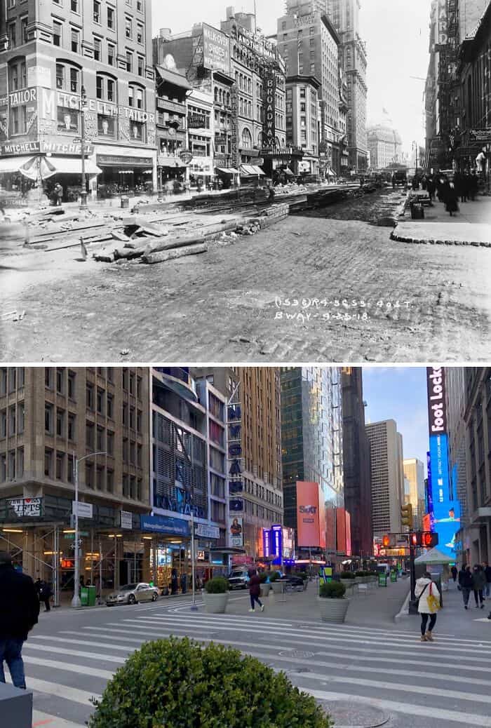
Looking north at Broadway & W 40th St in Midtown, Manhattan.
The old photo shows Broadway when the Theatre District extended farther south of its current boundaries centered around and north of Times Square and 42nd Street. Over the next few decades, this would gradually change as ‘Broadway’ moved north and the area south of 42nd Street became more manufacturing; retail; and commercial-oriented.
Also, note the roadwork taking place in the 1918 photo. This was likely the repaving and restoration of Broadway’s road surface after the construction and opening of the underground BMT Broadway Line which had been built using the cut-and-cover method.
40. 1979 & Today

Facing SW across the East River from below the Manhattan Bridge in DUMBO, Brooklyn.
The Twin Towers formed part of a complex of 7 buildings that was collectively known as the World Trade Center. Designed by architect Minoru Yamasaki, construction of the WTC began in the late 60’s. The North Tower was completed in 1972 & the South Tower was finished in 1973. Each tower stood at 110 stories tall & were the tallest buildings in the city; 1 WTC being the taller of the two as a result of its antenna spire.Combined, the towers provided nearly 10 million sq ft of office space for about 35,000 people. The World Trade Center complex was truly a city within a city.
During the 3 decades that they stood, the Twin Towers became an integral part of the New York’s cityscape. And how could they not? When one thought of the city, the image of the Twin Towers came to mind just like Central Park, the Empire State Building, & the Statue of Liberty. If you watched any tv show or movie set in NYC during that time, chances are the Twin Towers are prominently featured in at least 1 scene. The feeling of awe & wonder one must’ve felt simply gazing up at them from the ground below will surely forever be ingrained in the minds of those who beheld them. One simply couldn’t imagine New York without them always being there until the end of time… Today, the new One World Trade Center, completed in 2014, stands just north of the former site of the North Tower & holds the title of the tallest building in the city and the Western Hemisphere.